Although small satellites pose an exciting and important space situational awareness (SSA) problem, large satellites represent a much larger investment of engineering time and effort, and are ultimately responsible for delivering the space-based services we rely on in modern life.
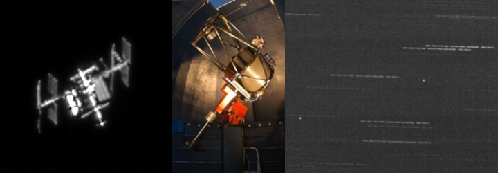
Many large satellites have angular diameters within the theoretical diffraction limit of moderately sized telescopes. However, atmospheric turbulence known as “seeing” causes the satellite image to be blurred by the time it reaches the ground. OSCOM is working on the development of techniques that approach the diffraction limit of the optical system in order to maximize the utility of moderate sized telescopes. The image of the International Space Station (ISS) at the top of the page is one early example of OSCOM’s use of 20″ Planewave CDK (Corrected Dall-Kirkham) for lucky/speckle imaging to resolve sub-seeing features from a sea-level observatory ( (Daytona Beach, FL).
Satellites in geosynchronous orbit are trivial to track, but require long term monitoring to identify meaningful optical features. Similar to what OSCOM is doing for unresolved LEO satellites, by modeling the optical and spectral components of the solar reflected light, it is possible to develop a picture of the basic physical characteristics of the satellite. The video below showcases our tracking and imaging capability of GEO satellites.